

For people who care about solving climate challenges but struggle to identify their root causes, we use the 5 Whys technique to uncover underlying problems and inspire creative solutions.
Here’s how it works: “XXX happens. Why? Because YYY.” “YYY happens. Why? Because ZZZ.” Keep asking “Why?” until you’ve explored five layers of causes. Then, suggest one creative way to address a cause identified in your list.
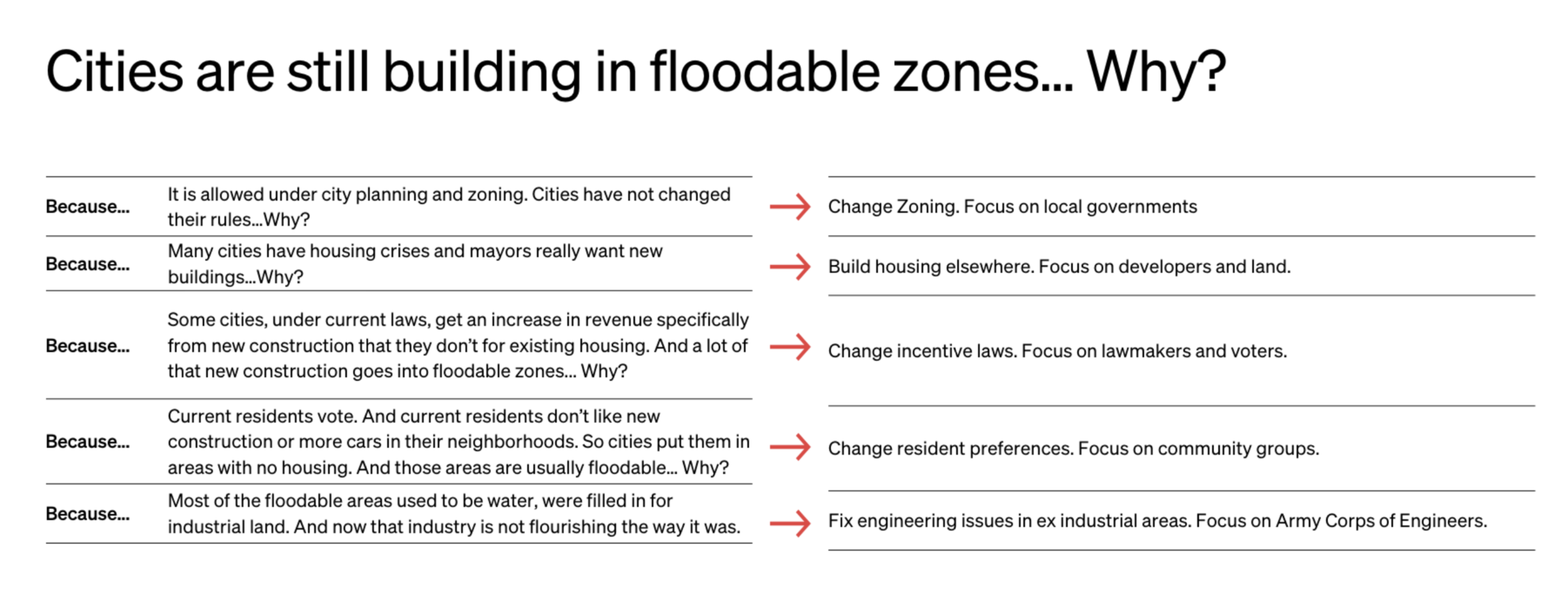
For example:
Now it’s your turn: Apply the 5 Whys technique to a climate issue you care about, explore five layers of causes, and propose one creative solution that addresses one of them.
Comments (34)
Cities keep building houses in flood zones, putting families in danger as extreme weather worsens.
1) Outdated Rules: City zoning maps are old, so local laws still legally allow building on floodplains.
2) Housing Crises: Huge housing shortages force mayors to rush any new construction approval just to get homes built.
3) Tax Systems: Current laws reward cities financially for breaking new ground rather than maintaining existing areas.
4) Local Pushback: Residents in safe, dry neighborhoods vote down apartment blocks to avoid extra traffic on their streets.
5) The Forced Choice: Councils feel trapped, pushing developers onto empty, low-lying old industrial wetlands that flood easily.
The Fix = Change how cities make money. Governments should give cash bonuses to councils that approve apartments in safe, established dry areas. Rewarding upward growth over spreading out naturally stops developers from building on dangerous wetlands.
My 5 Whys Analysis: Climate Mobility in Southern Brazil
Climate Issue: Communities displaced by climate-induced floods in southern Brazil (like the 2024 Rio Grande do Sul floods) struggle to integrate and rebuild their lives in host cities.
Why? Because they face severe barriers to stable housing, economic inclusion, and mental health support.
Why? Because local municipal systems are overwhelmed by sudden demographic shifts and rely on short-term emergency responses.
Why? Because there is a lack of localized data and structural frameworks to predict and plan for climate migration.
Why? Because policymakers still treat climate mobility as a temporary humanitarian crisis rather than a permanent socio-economic reality.
Why? Because there is no continuous, participatory feedback loop between displaced communities and local authorities to co-design urban policies.
The Fix = Create a "Climate Mobility Integration Lab." This would be a youth-led, participatory platform where displaced people and local youth map their own integration journeys in real-time (housing, jobs, health) and co-design policy recommendations directly with local municipalities. By shifting from top-down emergency aid to bottom-up, community-led data, cities can proactively plan for inclusive, climate-resilient urban spaces.
I’d love to hear how others are applying the 5 Whys to climate challenges in their regions! 🌍
This is so cool!! I love how you are thinking across time here. Which decision makers do you think need to be involved/adopt the recommendations of this lab? What do they care about today (access to resources, decision making power...)? Is this something every city would have (in case any city gets an influx of people) or just some cities that are seen as the safe havens?
Rebekah i-lab Thanks, Rebekah! Key actors would be municipal social services, housing, health, and urban planning, plus state migration bodies, MJSP, CONARE, and partners like ACNUR and IOM. Each cares about different things — visible results, budget justification, policy coherence, or measurable impact — so the lab's role is to translate community data into their language. I think every city needs some capacity, but the model can scale: full labs in cities like Ponta Grossa that already receive migrants, lighter versions elsewhere connected to regional hubs. At Fikra, we already do part of this informally — the lab would make it systematic and ensure migrant voices shape policy, not just consultations. Would love your thoughts!
Applying the 5 Whys technique to recurring urban and seasonal flooding in Ghana (Accra or Kumasi)
Climate Issue:
Severe seasonal and flash flooding in urban areas across Ghana, displacing communities, destroying infrastructure, and worsening health crises.
1) Why does severe flooding repeatedly devastate Ghanaian urban centres?
Because stormwater overflows major drains and waterways, rapidly flooding residential and commercial neighbourhoods.
2) Why do stormwater drains and waterways overflow so quickly?
Because many primary drainage channels and natural watercourses are heavily blocked by solid waste (plastic trash) and silt.
3) Why are waterways chronically clogged with waste and sediment?
Because rapid urbanisation has outpaced municipal waste collection infrastructure, and communities living in informal settlements lack reliable waste disposal services.
4) Why has local infrastructure failed to keep pace with urban growth?
Because city planning and municipal financing struggle to formalise and service rapidly expanding informal settlements built in low-lying, high-risk flood zones.
5) Why do vulnerable populations continue to settle in dangerous, low-lying flood zones?
Because a severe housing deficit, high land costs, and rural-to-urban migration force low-income families to occupy cheap, unprotected wetlands and river buffers.
The Fix: Community-led waste-to-asset infrastructure.
To break this cycle at its roots, cities should establish decentralised, youth-led cooperative hubs in vulnerable neighbourhoods that tackle both housing/drainage pressures and plastic pollution simultaneously
This is so interesting! It feels like you really could have very very different startups if you address level 2 vs level 4 vs level 5. Your current fix combines all of them but I might separate them. I'm intrigued by level 2. Have you talked with Judith Tukahirwa Tumusiime? She did tons of plastic clean up in Kampala Uganda. https://www.cityleadership.harvard.edu/wp-content/uploads/2026/02/BHCLI…
Rebekah i-lab , I will look her up.
Thanks for sharing.
landscape degradation and rural poverty in northern Cameroon:
1. Why ? Because the topsoil is undergoing intense wind and water erosion that washes away all fertile nutrients.
2. Why ? Because there is no longer any protective forest or vegetation cover left to bind the soil matrix and break the force of the Sahelian winds.
3. Why? Because local trees have been massively deforested by communities for firewood, and free-roaming livestock continuously trample and destroy any natural young saplings.
4. Why? Because smallholder families lack immediate alternative energy sources and regular financial revenues, preventing them from investing time or resources into protecting plots.
5. Why ? Because traditional reforestation campaigns completely exclude local populations from financial management and fail to deploy irrigation technology adapted to extreme Sahelian heat, making tree maintenance economically unviable for the village.
Solutions : replace industrial machinery with local craftsmanship by commissioning rural women artisans in Lagdo to produce porous clay jars that are buried directly near the roots of 4,000 native trees . Through a targeted HIMO-powered framework, local community guards and farming families receive direct cash-for-work payments to monitor the site and fill these jars. In return, the community cooperative gains exclusive rights to harvest, transform and sell the fruits of all the trees.
Excellent 5 Whys breakdown, Reine. Your clay jar irrigation and cash-for-work model is a brilliant way to sustain rural livelihoods. At Associação Fikra in Brazil, we know that when these rural ecosystems collapse, it forces families to become climate migrants.
By making rural living viable, your solution actually prevents forced migration. For those who have already moved, we need to adapt similar cash-for-work and green skills models to help migrant families rebuild their lives in host cities. Let's connect!
I love this! In particular making sure that farming families themselves see the benefit is key. Take a look at what EarthAcre is doing to make sure that the benefits of nature restoration are felt by individual families. Viraj is doing this in Kenya but so applicable to what you are doing here. https://www.earthacre.com/inthenews
Rebekah i-lab thank you for sharing ! I Will look into it 🙏🏽
Amr Elmallah Thank you for this exhaustive observation and what a great job you do through Fikra!!
Problem: Floods and landslides destroy homes, damage farms, and cause loss of lives.
1. Why? Heavy rainfall triggers flooding and landslides.
2. Why? Rainwater flows rapidly down slopes, carrying soil, rocks, and debris.
3. Why? Steep terrain and exposed or unstable soil increase the risk.
4. Why? Some settlements and farms are located in vulnerable areas, and protective measures may be inadequate.
5. Why? Risk mapping, land-use planning, early-warning systems, and disaster preparedness may be insufficient.
Great breakdown, Jasco. Inadequate land-use planning and early-warning systems disproportionately affect migrants. At Associação Fikra in Brazil, we see how newcomers are often forced into precarious, high-risk housing due to a lack of financial options. Even when early warnings exist, they often fail to reach migrants due to language barriers. We must ensure disaster preparedness and risk mapping are inclusive of migrant communities. Let's connect!
Hamida Balbool has been working on these areas-- I'd be delighted to connect you.
Climate issue: Why are the Himalayas experiencing devastating flash floods, glacial lake outburst floods (GLOFs), landslides, and other natural hazards?
1. Why are these disasters causing significant damage in the Himalayas?
2. Why do these disasters continue to cause severe losses despite scientific warnings?
3. Why are scientific findings often acted upon only after a disaster occurs?
4. Why do policymakers fail to enforce stricter preventive measures?
5. Why does tourism and development sometimes take precedence over people's safety?
My proposed solution: Shift from disaster response to disaster prevention by making scientific risk assessments an integral part of policymaking. After every major disaster, authorities should investigate whether similar climatic, geological, and environmental conditions exist in other Himalayan regions and take preventive action before another tragedy occurs. Credible scientific warnings should trigger timely risk assessments, effective early-warning systems, and enforceable regulations. Tourism and adventure activities must be restricted or temporarily suspended in high-risk areas whenever public safety demands it. Although relocation can be challenging, protecting vulnerable communities must take precedence over tourism revenue. Adventure travel can wait; people's lives cannot.
Excellent breakdown, Pranshu. Prioritizing lives over tourism and shifting to prevention is absolutely critical.
When these disasters hit, they inevitably force local communities to become climate migrants. At Associação Fikra in Brazil, we receive people who have lost everything to environmental shocks and must rebuild in new cities.
To truly protect vulnerable people, early-warning systems and relocation plans must be inclusive of displaced communities, overcoming language and social barriers. How do you envision integrating newly displaced people into your prevention framework? Let's connect!
Amr Elmallah Brief version for Himalayas — Inclusive Prevention Framework:
Problem:Himalayas = youngest, fractured mountains + glaciers melting 2x faster + permafrost thaw + extreme rain(easy way how I can put up). Science warns, but warnings are in English, technical, and split between departments. Tourism revenue beats safety because risk falls on locals.
My Shift: Response → Prevention
1. Trigger-Based Audit:After every major GLOF/landslide/flood, mandatory 90-day audit of ALL other valleys with same climatic + geological + glacial conditions. Don't wait for next disaster.
2. Inclusive Early Warning:
- Local dialect + voice + pictorial warnings, not just apps
- Map _people_, not just lakes — seasonal workers, migrants, elderly
- Paid local women/youth as "risk interpreters"
3. Tourism Safety Rule: High-risk zone = automatic restriction/suspension of adventure tourism when warning crosses threshold. Lives > revenue. Compensation fund for locals who lose income.
4. Integrating Displaced:
- Temporary ID for health/school/work without local proof
- Cash + host-family, not big camps
- Use displaced people's memory of changing rivers/slopes to update hazard maps
- Voluntary relocation to safe, pre-built land _before_ next monsoon, with livelihood support
Core line is if warning can't be understood by the poorest person in valley, it's not a warning.
Fnu Pranshu This is brilliant, Pranshu. Your point about mapping people and providing temporary IDs without local proof is exactly what is needed. At Fikra in Brazil, we know how lack of documentation blocks displaced families from accessing basic services. Using their memory of changing rivers to update hazard maps is a powerful, inclusive tool. I completely agree: a warning that the poorest or a newly arrived migrant cannot understand is useless. Let's stay connected!
Amr Elmallah Yes ofcourse. Lets stay connected. I remember from my field work when I was in Himalaya. I met old couple and they were narrating about how much changes they have experienced since childhood in terms of weather, precipitation and that made me think why do we directly not engage with local community and talk more to them then ourselves designing stuff and making sure if everything will fall in place or not.
Fnu Pranshu That is a powerful insight, Pranshu. Lived experiences are always more valuable than designing from a desk. At Fikra, we apply this exact principle with migrants. We don't assume what they need; we listen to their stories first to build effective integration programs. Just as those elders hold decades of climate memory, migrants hold the key to their own integration. Let's definitely stay connected!
Amr Elmallah Exactly and I personally feel accomplishment or satisfaction when process of any climate action takes into consideration its community. I mean you can never go wrong in this process.
Fnu Pranshu Absolutely, Pranshu. When the community leads the process, the impact is always deeper and more sustainable. At Fikra, we apply this by ensuring that migrants themselves are active co-creators of their own integration journey, not just passive beneficiaries. It’s great to connect with someone who shares this people-first approach. Let's stay connected!
Amr Elmallah I want to take this opportunity to ask does Fikra has career options for someone like me transitioning into science policy ? I mean are there any suitable roles for me which I can work remotely on? I would much appreciate it :)
“Greenhouse gas emissions from global consumption continue to rise, harming the planet. Why? Because sustainable consumption patterns are not widely adopted by everyday consumers.”
“Sustainable consumption patterns are not widely adopted by everyday consumers. Why? Because consumers face a 'green gap' where they struggle to find, trust, and consistently buy authentic green products.”
“Consumers face a 'green gap' where they struggle to find, trust, and consistently buy authentic green products. Why? Because green brands struggle to achieve strong green brand equity and effectively market their sustainable FMCG products to the public.”
“Green brands struggle to achieve strong green brand equity and effectively market their sustainable FMCG products to the public. Why? Because individual businesses lack the specialised green marketing frameworks, scientific consumer data, and unified multi-stakeholder networks needed to shift market behaviour at scale.”
“Individual businesses lack the specialised green marketing frameworks, scientific consumer data, and unified multi-stakeholder networks needed to shift market behaviour at scale. Why? Because historically, there has been a disconnect between local market actions and global sustainability platforms that unite consumer information with actionable local retail ecosystems.”
To address the core bottleneck where green brands lack unified networks and retail point of sale platforms to build brand equity (Layer 4), Greenics Consultancy leverages its role in the global One Planet Network (OPN) multi-stakeholder partnership—specifically within the Consumer Information for Sustainable Consumption and Production Programme.This is a clear, precise, and efficient solution that directly mirrors our overall goal and mission to drive clean consumerism. By operating as a curated, online marketplace for verified green Fast-Moving Consumer Goods (FMCG) Globally, we integrate global sustainable consumption guidelines with an accessible digital retail ecosystem. This efficiently closes the "green gap" by giving manufacturers and producers immediate market visibility while providing everyday consumers and governments with a trustworthy, direct avenue to make green lifestyle choices part of their routine and National data metrics for reporting purposes, businesses are able to get real-time data on behavioural intelligence and production planning processes to curb overproduction and pollution waste.
*In the context of the 5 Whys breakdown provided above, Layer 4 represents the structural business problem where sustainable brands fail to build long-term value, trust, and influence (equity) because they lack the proper tools, data, and collaborative networks to change consumer habits.
Great breakdown, Susan. Your digital marketplace solution to close the "green gap" is highly needed.
However, we must ensure this platform is inclusive of migrants. At Associação Fikra in Brazil, we see how newcomers, facing language barriers and a lack of local knowledge, easily fall prey to misleading claims.
If your retail ecosystem provides multilingual product information, it could empower displaced families to make safe, sustainable choices while rebuilding their lives. Let's connect!
The root cause behind the devastating flash floods, GLOFs, and landslides in the Himalayas is accelerated climate warming, as the 'Third Pole' warms faster than the global average.
This thermal rise drives rapid glacial retreat, forming unstable glacial lakes (leading to GLOFs), while altering monsoon dynamics into extreme precipitation events (cloudbursts). Combined with permafrost thaw and unmanaged infrastructure development, the structural stability of slopes is severely compromised. Addressing this requires a combination of real-time monitoring systems, nature-based stabilization, and climate-resilient local governance."
Excellent analysis, Israa. The cascading effects of warming in the Himalayas are truly devastating.
When these sudden disasters strike, they inevitably force mountain communities to become climate migrants, leaving behind their homes and traditional livelihoods. At Associação Fikra in Brazil, we focus on how host cities can integrate these displaced populations.
We completely agree that climate-resilient local governance is key. But we must also ensure early-warning systems and relocation plans are inclusive, reaching vulnerable people in a language they understand. How can we better prepare host cities to receive them? Let's connect!
Wow... I love the topic and I love the comments too. This reminds me of different challenges our community/country is facing and mostly we look the problem from it's consequences and not their roots. And this is why we fail in most of our problem.
You are absolutely right, Robert. Focusing only on symptoms is a trap that prevents real change.
At Associação Fikra in Brazil, we see this with migrant integration. People often look at the consequences—like housing instability or unemployment—without addressing the root causes: language barriers, lack of documentation, and social exclusion.
By using tools like the 5 Whys, we can dig deeper and design lasting solutions for displaced families rather than just temporary fixes. Let's connect!
Guys when is the link for the 22nd October Recording
Climate Challenge: Water Pollution and Unsafe Waste Dumping 🌍💧
I believe that protecting our environment starts with understanding the root causes of the problems affecting our communities. Through KUV Show and Tell Champions, I want to encourage communities to take action using the resources and knowledge we already have.
The 5 Whys
1. Why are our streams and water sources becoming polluted?
Because broken sewage lines, illegal dumping, and poor waste management allow harmful waste to enter our water systems.
2. Why does this waste continue to enter our water systems?
Because waste is not always managed properly, and environmental problems are sometimes reported too late.
3. Why are these problems reported too late?
Because community members may not know how to report them, who to contact, or how to document the problem.
4. Why do communities lack this information and involvement?
Because environmental awareness and monitoring are often not accessible enough at grassroots level.
5. Why is grassroots participation important but often limited?
Because communities are not always given simple, practical ways to participate in environmental protection and hold the relevant stakeholders accountable.
My creative solution 💡🌱
I would like to use KUV Show and Tell Champions to encourage community members and young people to become environmental ambassadors. Through a simple WhatsApp-based reporting system, people could share photographs and locations of polluted streams, blocked drains, illegal dumping, and water leaks.
This information could help communities build a record of environmental concerns to share with the relevant local authorities and ward committees. At the same time, we can promote a circular-economy mindset by exploring how waste materials, such as plastic and steel drums, can be safely transformed into useful products rather than discarded.
For me, climate action is not only about identifying problems; it is about empowering ordinary people to become part of the solution. Every waste stream has the potential to become a product, and every community has the potential to become an agent of change. 🌍♻️
Great 5 Whys breakdown, Thandeka! The WhatsApp reporting system is a brilliant, accessible idea. At Associação Fikra in Brazil, we work with migrants who often settle in areas with poor sanitation but are excluded from local reporting due to language barriers. We should ensure these tools are multilingual and actively involve migrant youth as environmental ambassadors. This would empower them to advocate for their own neighborhoods and build a sense of belonging. Let's connect!
Women in Kajiado, Kenya, spend hours each day collecting clean water. The reason is that the nearest reliable water point is far from their homes. That distance exists because water points are concentrated in a few locations rather than spread across the settlements where families live. Those locations are chosen based on plans that do not reflect how households actually move and live. The plans fall short because the women who rely on the water are rarely consulted when decisions are made. And there is no structured channel that allows climate-affected women to share their experience with policymakers.
The root cause, then, is the lack of a structured channel for affected women to shape water planning. A creative way to address it is to run "walk and map" sessions. Women lead small groups along their usual water routes and mark distances, waiting times, broken pumps, and safety concerns on a hand-drawn map that includes local landmarks. The maps go to local water authorities and become evidence in the policy brief, so decision-makers see the problem through the eyes of the people who live it every day. Since this chain is still a hypothesis, I will test it in the December conversations and adjust it based on what the women say.